The 1817 Census of Bareneed Number of inhabitants in the Harbour of Brigues, Cupids, Bear Need and Port de Grave ending September 27th 1817 was compiled by Capt Buchan RN. The Governor was away for the summer and did not return until September 30th, shortly after the date of this report. Buchan likely compiled the information for the Governor to prepare for what was expected to be another bad winter (food shortages and riots) in Newfoundland.
The following Table presents the information in the 1817 Census for Bareneed (Bear Need). The Table was compiled from the transcription on the Newfoundland’s Grand Banks Web Site; however, I have corrected several errors based on the original written version (see copy MUN Digital Archive). For example, the Supplier Pack was transcribed as W. Pack but my interpretation is Mr. Pack, Bay Roberts. I have also restructured the population data into three categories: Children, Servants (now includes M & F) and Total.
| # | Name | Children | Servants | Total | Supplier | Status |
| 2 | Th’s Boon Senr | 3 | 5 | Mr. Pack, Bay Roberts | Distressed | |
| 3 | Ab’m Boone | 4 | 6 | Graham Bare Need | ditto | |
| 4 | Jacob Hall | 3 | 4 | 9 | Pack | Well off |
| 5 | Th’s Boon John Son | 4 | 5 | 11 | Pinsent | D |
| 6 | Th’s Boon Wm Son | 4 | 6 | Pack | Distressed | |
| 7 | Wm Boone | 1 | 3 | Pack | ditto | |
| 8 | Ch’s Boone Abm Son | 1 | 3 | 6 | Natale & Cawly | ditto |
| 9 | Th’s Boon Junr | 2 | 1 | 5 | John Moore | ditto |
| 10 | John Boone Abm Son | 2 | 1 | 5 | Graham | ditto |
| 11 | Ben Batton | 5 | 1 | 8 | Johnston | well off |
| 12 | Sam Batton | 3 | 2 | 7 | ditto | ditto |
| 13 | John Batton Wm Son | 3 | 2 | 7 | Graham | ditto |
| 14 | John Batton Sam’l Son | 5 | 4 | 11 | Johnston | ditto |
| 15 | Edw’d Snow E son | 6 | 8 | John Moore | Distressed | |
| 16 | Wm Snow ditto | 2 | 4 | ditto | ditto | |
| 17 | John Snow ditto | 6 | 8 | Ths Bartlett | ditto | |
| 18 | Wm Snow Senr | 4 | 6 | ditto | ditto | |
| 19 | John Snow | 2 | 3 | ditto | ditto | |
| 20 | Edw’d Snow W Son | 2 | 1 | 5 | Ths Danson | ditto |
| 21 | Th’s Snow E Son | 2 | 1 | 5 | ditto | Well off |
| 22 | Ch’s Morgan | 2 | 4 | John Moore | Distressed | |
| 23 | Thomas Snow Snr | 1 | 3 | Graham | ditto | |
| 24 | Elias Picco | 2 | ditto | Well off | ||
| 25 | Jacob Delany | 1 | 1 | 4 | N & Cawly | D |
| 26 | John Boon Son Th’s | 5 | 7 | W Pack | Distressed | |
| 27 | Th’s Bartlett Senr | 3 | 2 | 7 | Sundry Merchants | all well off |
| 28 | Isaac Richards | 4 | 4 | 10 | Natale & Cawley | D |
| 29 | Wm Bartlett | 7 | 9 | Ths Bartlett | D | |
| 30 | Th’s Bartlett Junr | 6 | 1 | 9 | ditto | D |
| 31 | John Bartlett | 2 | 1 | 5 | ditto | D |
| 32 | John Richards Senr | 4 | 3 | 10 | Pencent | D |
| 33 | Elias Filleul | 4 | 6 | Ths Bartlett | Distressed | |
| 34 | Isack Filler | 2 | Ditto | ditto | ||
| 35 | Abr’m Filler | 2 | Ditto | ditto | ||
| 36 | John Filler | 2 | John Moore | ditto | ||
| 37 | John Moore | 2 | 9 | 13 | Pack | well off |
| 38 | Sam’l Stephens | 4 | 6 | Ths Bartlett | Distressed | |
| 39 | Benj’m Stephens | 2 | 4 | ditto | ditto | |
| 40 | Hard Stephens | 2 | 4 | John Moore | ditto | |
| 41 | John Bucham | 5 | 3 | 11 | Johnston | well off |
| 42 | John Curlew | 2 | 3 | Graham | well off | |
| 43 | Benjamine Curlew | 6 | 8 | ditto | Distressed | |
| 44 | Samuel Curlew | 1 | 3 | ditto | well off | |
| 45 | Dan’l Deleany | 5 | 7 | John Moore | bad off | |
| 46 | Sam’l Bradberry | 4 | 6 | Ths Bartlett | D | |
| 47 | Batt Corbin Senr | 1 | 1 | 4 | ||
| 48 | Batt Corbin Jnr | 2 | Edwd French | well | ||
| 49 | Phil Corban | 4 | 3 | 9 | ||
| 50 | Edward French | 3 | 1 | 6 | Graham | bad off |
| 51 | James Butler | 4 | 6 | 12 | Wm. Danson | well off |
| 52 | Wm Turner | 5 | 7 | Graham | ? only | |
| 53 | Philip Nule | 4 | 1 | 5 | Natale & Cawley | Well Off |
| 54 | Isaac Daw | 1 | 1 | Ths Bartlett | Distressed | |
| Total 158 | 6.1 avg |
The Survey was organized by town (Port de Grave, Bareneed, Cupids, Brigus) with Bareneed (Bare Need in Doc.) including people living at the head of Bay de Grave (Otterbury, Northern Gut, Clarke’s Beach, Southern Gut and Salmon Cove). The data for Bareneed was organized geographically in different sections likely representing the order in which it was collected.
The first section starts with Family #2 (#1 was blank) headed by Thomas Boon Senior who likely lived just east of the current wharf in Bareneed Cove and moves east to Jacob Delaney (#25) in the east end of Bareneed.
The second group starts with John Boone (#26), who likely lived west of Thomas (see above) and running in a general westerly direction (counter clockwise around the Bay) to a group of families with the Curlew surname (#42-#44). I am assuming that these families lived just east of the Dock Mountain.
The third Group which includes families #45 to #49 (see list below) were living in what is now the eastern end of the Otterbury which was sometimes referenced as Bradbury’s Hill in 19th Century documents (my best guess on location of Bradbury’s Hill is between 232 and 187 Otterbury Road, NL on Google Maps).
| 45 | Dan’l Deleany |
| 46 | Sam’l Bradberry |
| 47 | Batt Corbin Senr |
| 48 | Batt Corbin Junr |
| 49 | Phil Corban |
I have based my assumption on where these people in the third group were living based on land ownership in in the 1805 Plantation Book and post 1817 settlement patterns. For example, McAlpines Directory, 1870-71 had a separate grouping called the Bradbury’s Hill that included these family names and the 1901 Census had a separate division for Bradbury’s Hill which suggest that it was situated between the Otterbury and the Dock.
It is possible that some of the families with the Curlew surname (#42-#44) lived in Bradbury’s Hill since this family name is found in both the western end of Bareneed proper and the Bradbury’s Hill area.
The 4th Group (# 54 Isaac Daw to #50 Edward French) included people living in what is now The Dock.
I have assumed, based on my research, that # 54 Isaac Daw (Dawe) was the last resident on the list living in what is now Bareneed and that the remaining people in the list for Bareneed (> #54) were living in what are now the towns of Otterbury, North River, Clarke’s Beach and Salmon Cove (moving counter clockwise around the Bay).
The 1817 census not only listed householders but also included statistics on their wives, children and servants (M & F). In addition it includes the name of the supplier (merchant) each planter used and a general indication of their economic state (e.g. Well Off, Distressed). The following is a list of the Merchants and the number of planters they supplied.
| Supplier | Base | # Clients |
| Bartlett, Thomas | Bareneed | 13 |
| Graham (& Co.) | Scotland & Bareneed | 10 |
| Moore, John | Bareneed | 7 |
| Pack, Likely Robert | Bay Roberts | 6 |
| Johnston, William | Scotland & St. John’s | 4 |
| Natale & Cawley | Harbour Grace | 4 |
| Danson, William | Harbour Grace | 3 |
| Pincent, William | Port de Grave | 2 |
| French, Edward | the Dock / Bay Roberts | 1 |
| No Data | 2 | |
| Sundry | 1 |
This list is somewhat misleading since Graham (operating as Patten, Graham & Co) had difficulties 1816 and likely lost a number of clients prior to 1817. In addition, in some cases there were multiple layers with some small merchants using larger merchants as their supplier (see History 1805-1818 Section for more info on Merchants).
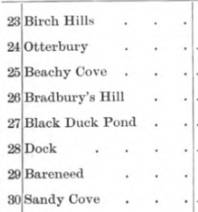
Families in the 1817 Census of Bareneed
The 1817 Census provides a snapshot of Bareneed at that point in time but in itself it provides a static view of the community. In an attempt to provide more context on the people recorded in this Census I have attempted to document the background and subsequent life of the people who were living in what is now Bareneed in 1817. This analysis is organized in a west to east direction in the following order:
- The Dock #54 Isaac Daw to # 50 Edward French;
- Bradbury’s Hill # 49 – #45 was excluded since now Otterbury;
- Western Bareneed # 44 Samuel Curlew to #33 Elias Filler;
- Mercers Lane to Shop House Hill #32 John Richards Senr # 27 Thomas Bartlett Senr. ;
- The Cove #26 John Boone to #14 John Batton Sam’l Son (note order of numbering system changes);
- Eastern Bareneed #15 John Batton Sam’l Son to #25 Jacob Delaney.
To make the files more manageable I have divided the list into separate files. The first group which covers The Dock (#54-#50 in 1817 Census) is presented below. Subsequent sections are presented in separate files starting with western Bareneed which is in the file Census 1817 Part II .
1817 Census, Section I The Dock
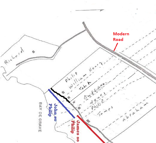
The following Map shows The Dock (western part of Bareneed) with the ocean frontage (width) of the Plantations listed in the 1805 Plantation Book.
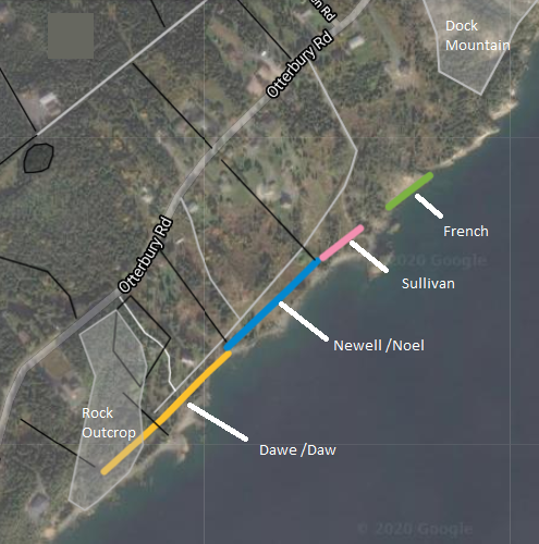
#54 Isaac Daw / Dawe:
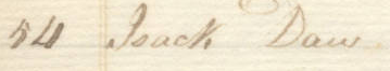
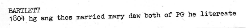
In the 1817 Census Isaac Daw is listed with his wife and one child and is described as “Distressed”. His supplier (merchant) is listed as Thomas Bartlett who was a local Planter/Merchant in Bareneed. It is possible that they were related since in 1805 a Thomas Bartlett married a Mary Daw.
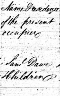
This was likely the same property listed as belonging to Samuel Dawe in the 1805 Plantation Book.
Under the name of the person presently occupying the plantation in 1805 it gives Samuel Dawe Children which may suggest that the land had transferred to Samuel’s children.
The Daw /Dawe family was one of the first to settle in Port de Grave and likely had fishing operations there when John Guy arrived in 1610 (Gerald W. Andrews, 1997). Isaac was the only Daw listed in the 1817 Census as living in Bareneed but in the same census there were 23 Daws listed as living in Port de Grave and surrounding Coves and 3 as living in Cupids.
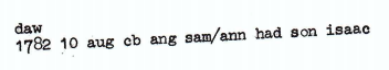
In 1782 a Sam and Ann Daw had a son Isaac who would have been in his mid 30s in 1817. This Isaac fits with the Isaac Daw of Bareneed who was buried in 1833 with his age given as 52 years.
In the 1817 Census Isaac Daw is listed with his wife and one child. If he is the Isaac who died in 1833 then he would have been in his mid 30s in 1817 so it is possible that he had more children after this. There is no evidence of him having a son (which is not proof that he did not); however, there are several candidates for daughters two of whom married in December, 1830. These were: Grace who married Robert Turner (KN indicates that grooms name was Richard) who was likely the son of their neighbour William Turner (#52) and Providence who married Robert Tilley from Kelligrews. There was also of a Catharine Daw of Bareneed who married Henry Butler of PDG in October 1830 (source KN). It is difficult to reconcile these reports with the data for the 1817 Census which show Isaac only having one child in 1817. It is possible that some of these girls were:
- missed in the Census,
- were living elsewhere in 1817 (KN suggest with grandfather in PDG),
- or were Isaac’s sisters or other relatives who moved to Bareneed after 1817.
I currently suspect that Richard/Robert Turner may have acquired part of the Dawe property through his marriage to Grace Dawe and subsequently sold it to my great great grandfather John Newell (who owned the adjoining property to the east) in 1839 (record of sale from my early notes related to research by Harold Newell).
A Web Site The Descendants of Issac Daw and Rebecca Beecham has this Bareneed Isaac being the son of Isaac Daw (Sr.) of Cornwall and Rebecca Beecham (Beauchamp) of Bareneed. This might fit if Isaac of Bareneeed was a nephew of Samuel but there is not sufficient strong evidence to support either argument.
Another possible theory is that the Samuel Daw listed as the owner of the Bareneed property in 1805 was Samuel of Port de Grave (i.e. owned multiple properties) and that Isaac was his son and was living there in 1817. Under this theory after Isaacs death the property transferred to other members of the family.
For more information on later members of this family see the Dawe Family page under Family Names of Bareneed.
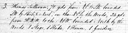
#53 Philip Nule/Noel/ Newell
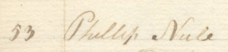
Philip Nuel is listed in the 1817 Census as having a wife, 4 children and one man servant. His Supplier (Merchant) was listed as “Natale & Cawley” ( Nuttall & Cawley, Harbour Grace fish merchants) and he was described as “well off”.
This is the same Philip listed in the 1805 Plantation Book as Philip Noel and listed in a 1820 copy of the Plantation Book record that I still have as Philip Newell (see below).
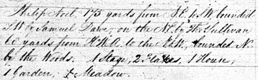
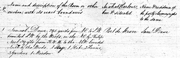
Transcript of 1820 copy of above: “Philip Newell 175 yards from NE to SW bounded SW by Samuel Dawe on the NE by Thomas Sullivan 68 yards from HWM [High Water Mark] to the N by W bounded N by the woods. 1 stage 2 flakes 1 home 1 garden 1 meadow_____ Cut and cleared agreeable to the act of Wm 3. [King William III] Chap. 25, Sect 7 ____________ date of Entry 1785 ________The foregoing is a true Copy taken from the records this 28 day of Jan 1820. I still have the original of this 1820 copy and Philip likely had it made for his records.
The approximate east/west extent of Philip’s Plantation is shown on the earlier Map (see discussion of Isaac Daw above).
This Philip was my 3X great grandfather and his family is described in more detail in other sections of this Web Site. In November 1784 Philip married Amy Batton [of Bareneed] at St. Pauls’ Church, Harbour Grace. At that time this was the closest Church to ‘the Dock’ (~20 km north ) and many people from other communities in Conception Bay were married there.
Philip was also referenced as Newall in a 1819 Court Case.

Philip had two sons James (1786-1849) and John (1793-1855, my 2X great grandfather). When Philip died the Plantation was divided between the two sons with John getting the western half and James the eastern half. After their deaths each part was further divided among their sons. One of John’s sons acquired a section of the Dawe Plantation.
In subsequent generations parts of the Newell Plantation were either sold or passed to other male lines through marriage; however, several sections of John’s property still remain in the family.
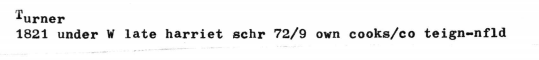
#52 William Turner
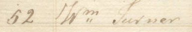
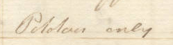
| 52 | Wm Turner | 1 | 1 | 5 | W Graham | ? only |
William Turner is listed in the 1817 Census as having a wife and 5 children, his merchant was W Graham (see discussion in History 1805-1818 section) and his “Means of Providing” is listed as what I interpret as “Potatoes only” (see my discussion of Agriculture).
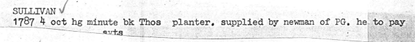
The property occupied by William Turner in 1817 was likely the same Plantation listed as belonged to Thomas Sullivan in the 1805 Plantation Book.
Unlike the Dawe and Noel Plantations described earlier which were dated as registered in 1785 and 1786 in the 1805 Plantation Book, this Sullivan Plantation was listed as registered in 1802.
There is very little information on this Thomas. There were other Sullivans who were planters in Carbonear, Harbour Grace, Bay Roberts and Harbour Main around this time so this Thomas might have been related to one of them. Most but not all of these were Roman Catholic. In 1784 there was a reference to a Thomas Sullivan who had dealings with Newman (merchant) Port de Grave.
In 1814 a Thomas Sullivan of Little St. Lawrence left clothing to wife of John Butler. This might be significant since in 1817 a Butler owned property near the Sullivan Grant (see #51 below).
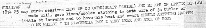
Basically the last record to Thomas Sullivan in the Bareneed records was in the Plantation Book of 1805.
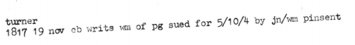
William Turner of Port de Grave was involved in at least two court cases between 1817 and 1818.

During the early 1800s a William Turner was master of several vessels sailing between Poole and Newfoundland and later between Teignmouth (Teign) and Newfoundland (see example below) but it is not clear if this was the William from Bareneed.
In 1829 the Wife of William Turner was buried at Bareneed.
| (BLANK) TURNER, wife of William TURNER, Dock, Bearneed. N.D. | Mar. 22, 1829 |
On 14 December 1830 Richard or Robert Turner of Bareneed married Grace Daw of Bareneed (One transcription gives Robert but KN indicates that original was Richard not Robert). There was also a William Turner who Married a Mary Warford at Harbour Grace in January 1832 who might also be a son of William of Bareneed.
| 15 Jan 1832 | Harbour Grace | TURNER William | Bachelor | Harbour Grace | J. Burt | William Warford | |||
| WARFORD Mary | Spinster | Harbour Grace | John Parsons |
In 1834 a William Turner of The Dock (age 63 making his DOB c 1771) was buried at Bareneed.
| TURNER | William TURNER of the Dock. | 63 years | Jan. 21, 1834 |
The 1835 Voters List for the Dock lists a Richard Turner.
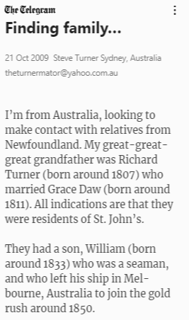
Records for a Turner family from Australia suggest that a Henry Turner son of Richard Turner and Grace Daw moved to Australia c 1850. Myself and several other descendants of Newells from The Dock have 4th & 5th cousin DNA matches to several descendants of this family.
This is supported by the burial records for this William Turner.
| Name: | Wm Turner [William Turner] |
|---|---|
| Birth Year: | abt 1832 |
| Age: | 69 |
| Death Place: | Alexandra, Victoria |
| Father’s name: | Turner Richd |
| Mother’s name: | Grace Daw |
| Registration Year: | 1901 |
| Registration Place: | Victoria |
In 1839 Richard Turner of the Dock sold land to my great great grandfather John Newell (from my early notes related to research by Harold Newell). This might be the land east of the Newell Plantation occupied by William in 1817; however, I suspect that Richard/Robert Turner may have acquired part of the Dawe property (land west of Newells see Isaac Daw above) through his marriage to Grace Dawe and subsequently sold it to my great great grandfather John Newell (who owned the adjoining property to the east).
#51 James Butler
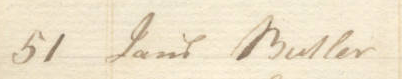
This record is incorrectly listed as Daniel Butler on the transcription posted on the chebucto.org site.
In the 1817 Census James Butler is listed as having a wife, 4 children, 5 man servants and 1 female servant. He is described as being “Well Off” and using William Danson as his supplier/merchant (again incorrectly given as Thomas Danson on the chebucto.org site). See History 1805-1818 Section for more information on Danson.
The Plantation Book of 1805 had several Butlers in Port de Grave but none in Bareneed. The Butler family was settled in Bay de Grave in the 1600s and were established there by the 1700s (A. M. Butler, 1975, pp 32-35). Based on the order of references in the Census of 1817 it is likely that the James Butler of 1817 was living on or near the land occupied by either Thomas Sullivan (see under William Turner above) or Edward French in 1805 (see Map of 1805 Plantations above).
There is a reference to a James Butler owning a vessel Industry in 1815 who is likely the James at Bareneed in 1817:

There are records for a vessel named Industry linked to a Richard Bransfield who is listed as living in Bareneed; however, this might be a reference to where the ship was built.
Industry built 1810
| Name: | Richard Bransfield |
| Record Type: | Owner |
| Residence Place: | Bareneed , Conception Bay, Newfoundland, Canada |
There is another reference to Richard Bransifield of Carbonear owning another ship built in Bareneed.
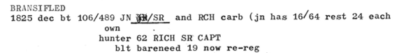
Given that Bareneed including the Dock was becoming a hub for shipbuilding and the Labrador fishery around this time (see History 1818-1837 Section) it is possible that James, who was living in The Dock in 1817, was either a owner, master or involved in shipbuilding. We do have evidence that he was living in Bareneed in 1815 and owned a boat in Northern Gut in 1816. These references suggest he had dealings with the Merchants Patten & Graham at this time but since they had numerous legal battles with their clients in 1817 this might explain why he he was listed as dealing with Danson as a supplier in the 1817 Census.
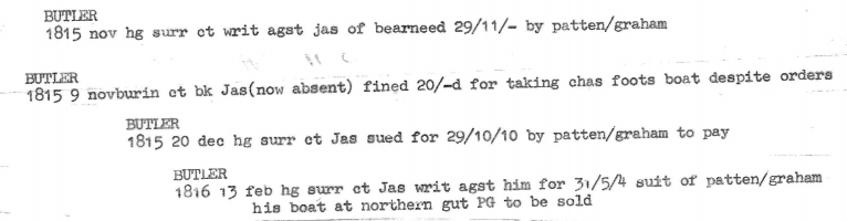
The following reference from 1817 shows that he owned a Schooner Seaflower from 1814- 1817.
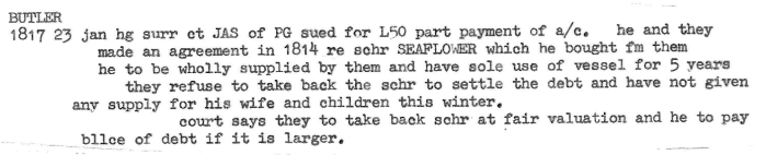
By 1819 he was insolvent but agreed to pay.

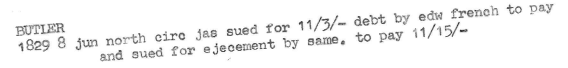
This James was likely still living in The Dock in 1829 since he was sued by his neighbour Edward French (see next Plantation).
Will of Edward French from Newfoundland probate year 1829. I Edward French, at the Dock, Bearneed ……. I give to my sons Joseph and Abraham, the house, ground and all thereunto pertaining belonging formerly to James Butler, and given to me by a decree of the court at Harbor Grace.
The Butler family at Riverhead, Port de Grave (Clarkes Beach/Northern Gut) in the 1830s may be related to these Butlers.
| Jan. 1, 1835 | John BUTLER | Riverhead, Port de Grave | Elizabeth BUTLER | Riverhead, Port de Grave |
#50 Edward French
Edward is listed in the 1817 Census as having a wife, 3 children, and one man servant. The Supplier/Merchant he dealt with is listed as Graham (See discussion of Graham in History 1805-1818 Section) and he is described as being “Bad Off”. French’s relationship with Graham is unusual since during this time the various Graham companies were in legal disputes with virtually all their clients but there is no record of disputes with Edward French. This is even more unusual given that Edward was described as “Bad Off”.
This Edward is likely the same person listed Plantation in the 1805 Plantation Book.
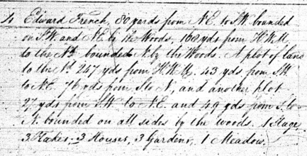
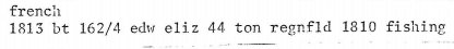
The French Plantation was registered in 1797, five years before the Sullivan Plantation but after the Dawe and Noel/Newell Plantations. This Edward was likely the son of Edward and Elizabeth French of French’s Cove, Bay Roberts. Seary‘s book Family Names of the Island of Newfoundland states that the families with the surname French arrived as long ago as 1634.
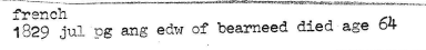
This Edward died in July 1829 (age 64, b c 1765) and his Will was probated in 1829.
Edward was apparently reasonably well off at the time of his death since his Legacy included:
- I bequeath to my wife, Mary, and to my son, Edward jointly all the monies which may be in England at the time of my death, together with the house, outbuildings and land, occupied and owned by me at the Dock, Bearneed at the time of my death.
- I bequeath to each of my children, the sum of One hundred pounds sterling (except my eldest and youngest sons, John and Edward French), these children were: Elizabeth Hussey, Joseph French, Ann Dawe, of Ship Cove, Abraham French and Mary Batten);
- I give to my four sons, John, Joseph, Abraham and Edward, the Schooner “Brothers” with all her materials, together with all the nets, seines, and every article used in the fishery, skiffs, boats, barking kettles, &c.;
- I give to my wife and my son Edward all my cattle & sheep to dispose of as they please.
The Schooner Brothers (65 Tons) was built in 1819 by Edward Snow of Bareneed for Edward French. Edward had previously owned the Schooner Elizabeth (44 tons) built in PDG in 1806.
Edward French may have acquired all or part of the adjoining land occupied Butler in 1817 as a result of legal proceedings in 1829 (see previous discussion of Butler Plantation).
Discussion of 1817 Census continued in Census 1817 Part II.