This Section is a continuation of the analysis of the 1817 Census of Bareneed; that Section introduced the Census and provided detail on the families enumerated in The Dock which is the westernmost part of Bareneed. This Section continues moving eastward and covers the families enumerated in that section of Bareneed east of the Dock Mountain.
I am assuming that the first property east of the Dock Mountain was #44 belonging to Samuel Curlew and the five properties listed below were in Otterbury / Bradbury’s Hill not Bareneed.
| 45 | Dan’l Deleany |
| 46 | Sam’l Bradberry |
| 47 | Batt Corbin Senr |
| 48 | Batt Corbin Junr |
| 49 | Phil Corban |
I have based my assumption that these families were living in the Otterbury / Bradbury’s Hill based on land ownership in 1805 (Plantation Book) and post 1817 settlement patterns (see previous Section for more discussion of this topic).
The following map shows the approximate location of the property occupied by different families in the western part of Bareneed as recorded in the 1805 Plantation Book.
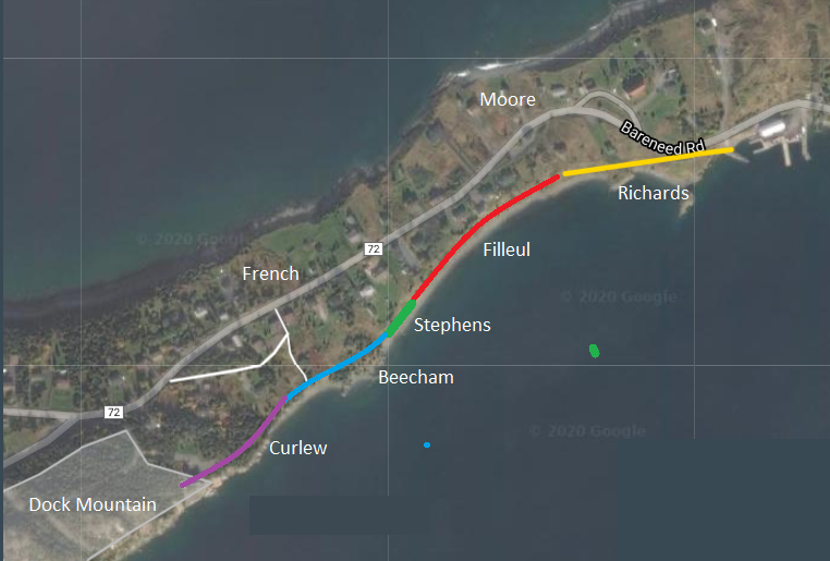
#44 Samuel Curlew, #43 Benj. Curlew & # 42 John Curlew
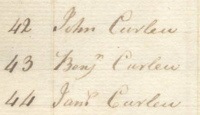
The next two properties after Samuel Curlew (#44) also belonged to families with the Curlew name (Benjamin #43 and John #42) and were likely related. I am making this assumption since the Plantation Book of 1805 has a John Curnew (varant of Curlew) occupying the land between the Dock and the property of John Bucham.
In 1817 the land east of the Curlews was still occupied by a John Bucham. In the mid to late 19th century some Curlew’s lived in Bradbury’s Hill as well as the western end of Bareneed proper and it is possible that #44 Samuel in the 1817 Census was part of this group. However, it is clear from the previous discussion that in 1817 the Curlews were the westernmost family in Bareneed.
John Curlew (#42) in the 1817 Census may have been the same John Curnew listed in 1805 since he had 2 children but no wife (widower). This John and Samuel are described as “Well Off” while Benjamin was described as Distressed. None had servants and all three used Graham as their Supplier/Merchant.
| 42 | John Curlew | 1 | 2 | W Graham | well off | ||
| 43 | Benj’m Curlew | 1 | 1 | 6 | ditto | Distressed | |
| 44 | Sam’l Curlew | 1 | 1 | 1 | ditto | well off |
See the Curlew Family section in Family Names Section for more information on this family.
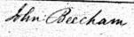
#41 John Beecham / Bucham
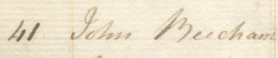
The Chebucto Web Site transcribes this as Bucham (see below) but it is likely Beecham (the spelling used by family in later records). The name was written in the 1805 Plantation Book as:
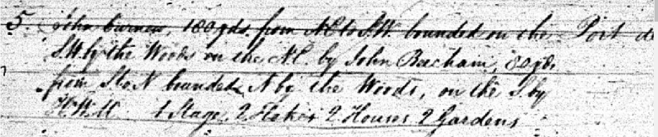
In the Plantation Book the grant is listed as 1769 making it earlier than John Curnew/Curlew to west and all the grants in the Dock (see previous section). It is interesting that in the 1970s my father (John Robert) had indicated that our ancestor Philip first came to the Dock with the Beechams. I interpret this as they came as servants/apprentices to the Beechams, no other support for this but given that the Beechams were established in 1769 (16 years before Philip got his grant) it would fit.
In 1810 there were two Beachams recorded; John of Port de Grave (Bareneed) owned a Schooner Brothers built there in 1810 and a William who sued an Edward Whealan.

In the 1817 Census the John Bucham/Beecham property is listed as occupied by 2 men and one woman (poss man and his wife plus elderly father), five children and three man servants
| 41 | John Bucham | 2 | 1 | 5 | 3 | W Johnston | well off |
John’s merchant was William Johnston a Scottish merchant who at this time was based in Port de Grave. This firm became Baine, Johnston & Co. in 1832.
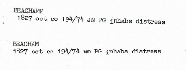
In 1827 there were references to a John Beachamp and a William Beacham living in Port de Grave (almost certainly Bareneed):
For more information on this family see the Beecham Family Page under Family Names.
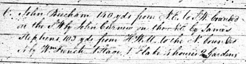
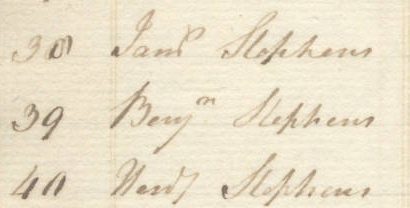
# 40 Hard Stephens, # 39 Benjamin Stephens & # 38 Samuel Stephens
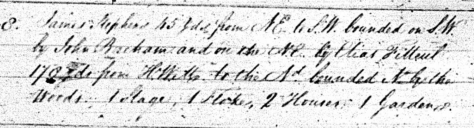
In the Plantation book James Stephens property was recorded as as “gift from his Mother” granted in 1770. The Church of England at Harbour Grace recorded the the Baptism on 31 Jan., 1816 at Bear Need of Anne daughter of James & Mary Stevens; however, James is not listed in the Census of 1817. This would suggest that the three Stephens listed in 1817 were his sons (Note #40 transcribed as Hard might be Harold or Henry).
| 38 | Sam’l Stephens | 1 | 1 | 4 | Ths Bartlett | Distressed | ||
| 39 | Benj’m Stephens | 1 | 1 | 2 | ditto | ditto | ||
| 40 | Hard Stephens | 1 | 1 | 2 | John Moore | ditto |
The Following Rachel Stevens who died in 1828 could be the widow of one of the three Stephens listed in 1817.
| Rachel STEVENS, Bareneed, Widow. | 80 years | Sept. 20, 1828 |
For more information on this family see the Stevens Family page under Family Names.
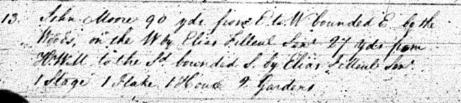
#37 John Moore
John Moore with a wife, 2 children, 8 man servants and 1 female servant is the next householder listed in the 1817 Census.
| 37 | John Moore | 1 | 1 | 2 | 8 | 1 | W Pack | well off |
His listing is followed by several members of the Filler family. This contrast with the !805 Plantation Book which list James Moore after three members of the Filleul family. The 1805 Plantation Book shows that John Moore was bounded to the West and south by Elias Filleul which suggest that his grant was east of Elias Filleul. Based on the description in the Plantation Book and later settlement patters it is likely that John Moore’s Plantation was situated facing a small cove on the Bay Roberts side of the Peninsula in an area known as Mercer’s Lane. This was the only possible landing area on the Bay Robert’s side, the coast to the west being cliffs and to the east exposed beach with no deep water. As a result the land was not developed on this side of the peninsula which explains why his property was bounded on the east by woods.
John Moore’s property was registered in 1804 just one year before the Plantation book was compiled (only one other property registered after 1800).
Church records from Harbour Grace show that John Moores was living at Bareneed as early as 1801.
| 20 Nov 1801 | Bareneed | MOORES | John & Mary | William |
Court records show that John Moors was the Constable at Bareneed and acted as a witness to a flogging (see History 1805-1818 Section for more info on this flogging)

See the Moore Family Web Page under Family Names for more information on this family.
# 36 John Filler, #35 Abraham Filler, #34 Isack Filer & # 33 Elias Filler.
These 4 members of the Filler family occupied the land between the Stephens / Stevens family and John Moore. The book Family Names of Newfoundland identify Fillier as a variant of the Channel Island name Filleul.
In the 1805 Plantation Book there were also 4 members of the Filleut (Variant) family living in the same general location.
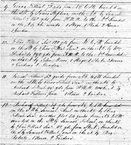
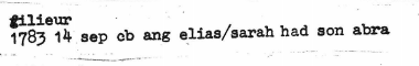
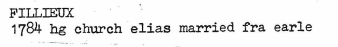
The Plantation Book of 1805 suggest that Elias Filleul Sr. had the original grant in 1760 and the others properties were inherited between 1763 and 1793.
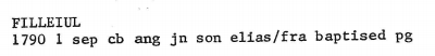
| E. Filleul Jr. | Bequeathed to him by his Father’s Will | 1790 |
| E. Filleul Sr. | Cut and cleared agreeable to Act Wm. 111 Chap.25 Sec.7 | 1760 |
| Sam. Filleul | Bequeathed to him by his Father’s Will | 1763 |
| Rd. Filleul | Bequeathed to him by his Father’s Will | 1793 |
By the time of the 1817 Census it appears that Ellias Jr. was living in the same location but that the other properties had changed hands likely to the next generation (see below). Isack, Abraham and John were all married but had no children. All four were described as “Distressed”.
| 33 | Elias Filler | 1 | 1 | 4 | Ths Bartlett | Distressed | ||||
| 34 | Isack Filler | 1 | 1 | Ditto | ditto | |||||
| 35 | Abr’m Filler | 1 | 1 | Ditto | ditto | |||||
| 36 | John Filler | 1 | 1 | John Moore | ditto |
In the 1817 Census the spelling of the family name had apparently changed to Filler and other records from this period record it as Fillier (see below).
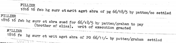
Abraham in the 1817 Census and above was likely a son of Elias Sr. and Sarah.
John may be the son of Elias Jr. and Frances born 1790 or the John who died in 1844 at age 85 (born c 1759).
| John FILLIER | Mar. 20, 1844 | 85 years |
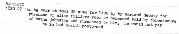
In 1819 Elias of Bareneed (likely Jr.) built the 64 Ton schooner hunter for Thomas Bartlett.

Elias Fillier’s land in Bareneed sold to Thomas Bartlett some time before January 27th, 1820.
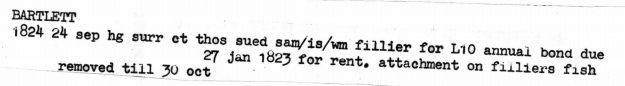
In 1824 Samuel, Isaac and William Fillier were renting from Thomas Bartlett.
See the Fillier Family Web Page for more information on this family.
Continued in Census 1817 Part III Section